
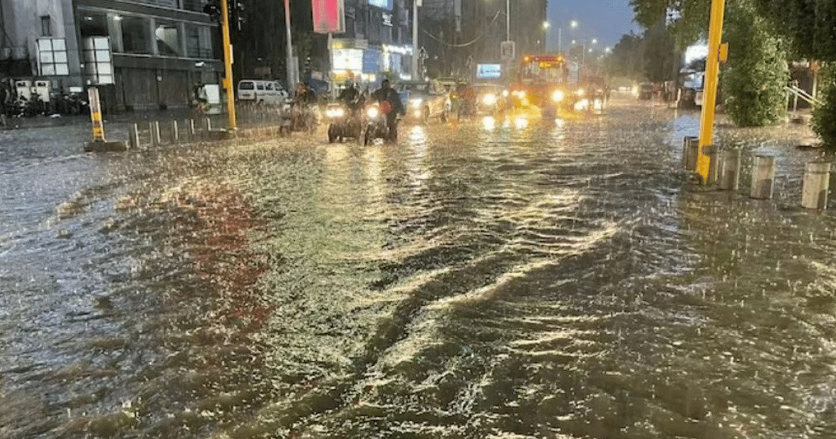
UP Weather Update: Due to monsoon activities in Uttar Pradesh, the rainy season continues. People have got relief due to light to moderate rain in different parts of the state. In the last 24 hours, it rained at many places including the capital Lucknow. According to the Zonal Meteorological Centre, Lucknow, the weather conditions indicate that there is no possibility of withdrawal of monsoon in the next few days.
UP Weather Update: Weather may change due to heavy rain
According to the Meteorological Department, there is a possibility of heavy rain once again in other states including Uttar Pradesh. There may be heavy and at some places very heavy rains on 21st and 22nd September. New circulation and low pressure areas are forming in many parts, so there are no signs of withdrawal of monsoon at this stage. There will be a delay in the withdrawal of monsoon. Usually the weather starts returning after 17th September.
UP Weather Update: Maximum level of humidity reached 95
Wednesday morning started with normal weather in the capital Lucknow and surrounding areas. The sky is slightly cloudy at some places. According to Zonal Meteorological Centre, Lucknow, there may be rain and thundershowers at one or two places in Western Uttar Pradesh and some places in Eastern Uttar Pradesh on Wednesday. During this period, there is a possibility of lightning along with thunder at one or two places in the entire state. Due to the change in weather, the maximum level of humidity has reached 95. In the capital Lucknow and surrounding areas, the maximum temperature on Tuesday is expected to be 35 degrees and the minimum temperature will be 27 degrees Celsius.
UP Weather Update: Chances of rain in these districts
According to Zonal Meteorological Centre, Lucknow, there are chances of light rain in Sonbhadra, Chandauli, Ghazipur, Ballia, Deoria, Mau, Azamgarh, Varanasi, Jaunpur, Mirzapur, Sant Ravidasnagar, Prayagraj, Chitrakoot, Kaushambi, Pratapgarh and Sultanpur on Wednesday. Are. Along with this, there are chances of rain in Kushinagar, Gorakhpur, Maharajganj, Sant Kabirnagar, Basti, Siddharthnagar, Gonda, Balrampur, Barabanki, Bahraich, Shravasti, Balrampur, Sitapur and Lakhimpur Kheri.
UP Weather Update: Possibility of clouds and lightning here
According to Zonal Meteorological Centre, Lucknow, lightning is expected in Mau, Ballia, Deoria, Gorakhpur, Sant Kabirnagar, Basti, Kushinagar, Maharajganj, Siddharth Nagar, Gonda, Balrampur, Shravasti, Bahraich and Lakhimpur Kheri districts. Apart from this, there is a possibility of thunder and lightning in Banda, Chitrakoot, Kaushambi, Prayagraj, Fatehpur, Pratapgarh, Sonbhadra, Mirzapur, Chandauli, Varanasi, Sant Ravidas Nagar, Jaunpur, Ghazipur and Azamgarh.
UP Weather Update: Chances of rain and lightning here too
According to meteorologists, Ambedkar Nagar, Ayodhya, Amethi, Rae Bareli, Fatehpur, Banda, Lucknow, Unnao, Kanpur Nagar, Kanpur Dehat, Hamirpur, Mahoba, Jhansi, Jalaun, Lalitpur, Hardoi, Shahjahanpur, Badaun, Sambhal, Amroha, Moradabad and Bijnor. There is a possibility of rain in also. Along with this, there is a possibility of thunder and lightning in Sitapur, Hardoi, Lucknow, Barabanki, Rae Bareli, Amethi, Sultanpur, Ayodhya, Ambedkar Nagar, Bijnor, Amroha, Moradabad, Rampur, Bareilly, Pilibhit, Shahjahanpur, Sambhal, Badaun and its surrounding areas. There is a possibility.
UP Weather Update: Rainy conditions in UP till September 25
According to Zonal Meteorological Centre, Lucknow, the rainy season continues in the state till September 25. There is no possibility of any major change in the maximum and minimum temperatures in the state during the next four days.
UP Weather Update: Cyclonic circulation status
According to the Meteorological Department, the area of cyclonic winds over the north-west and adjacent central Bay of Bengal extends up to 5.8 km above the mean sea level. Due to its effect, a low pressure area may be formed by the evening of 19th September. The cyclonic circulation over East Rajasthan is now situated over South Rajasthan and adjoining areas and extends up to 5.8 km above sea level. The pressure line is running from North Western Rajasthan to North Eastern Arabian Sea. The monsoon trough at mean sea level now passes through Jaisalmer, Kota, Guna, Ambikapur, Jamshedpur, Digha and then south-eastwards through east-central Bay of Bengal.